
Файл:60m artificial fumarole at el tatio geothermal field.jpg

Сығанаҡ файл ((900 × 595 пиксель, файл күләме: 294 Кб, MIME-төр: image/jpeg))
Был файл һаҡлау урыны Викиһаҡлағыста һаҡлана. Уның тураһында мәғлүмәттәр түбәндә күрһәтелгән.
Викиһаҡлағыс — Викимедиа проекттарында ҡулланылған ирекле файлдар өсөн үҙәкләштерелгән һаҡлағыс. |
Ҡыҫҡа аңлатма
| Тасуирлау |
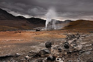
English: In 2008, the “Geortérmica del Norte” consortium - formed by Chilean state owned ENAP and Codelco mining companies in association with Italian Enel Green Power - began exploration in the "quebrada El Zoquete", near the El Tatio geothermal field in Chile's II Region, with the purpose of constructing a 40 MW geothermal plant. After months of exploration, an operating malfunction occurred in well No. 10 in September 2009, causing the eruption of a 60-m-high artificial fumarole which took away virtually all the pressure in the El Tatio complex. Although the company finally managed to close the well, damage was not limited to the visual. Ignorance of both guides and visitors - who were literally running all over the vents - caused extensive damage to the fragile mineral deposits, and the harm make take years, if not decades, to get undone. In fact, an earlier exploration attempt in the late sixties turned into disaster – even if only economically. |
| Көнө | |
| Сығанаҡ | Шәхси эш |
| Автор | Gerard Prins |
| Местоположение камеры | | Это и другие изображения по их местоположению на OpenStreetMap |
|---|
Altitude: 4334.00 m
Лицензиялау
- Һеҙгә мөмкин:
- бүлешергә – эште күсереп алырға, таратырға һәм тапшырырға
- үҙгәртергә – эште яраҡлаштырырға
- Түбәндәге шарттарҙа:
- авторлыҡты асыҡлау – Авторлыҡты, лицензияға һылтанманы һәм авторҙың ниндәй ҙә булһа үҙгәрештәр индергәнме-юҡмы икәнлеген күрһәтергә тейешһегеҙ. Быны теләһә ниндәй ысул менән эшләргә мөмкин, әммә лицензиат һеҙгә ярҙам иткән йәки ошо әҫәрҙе ҡулланыуығыҙҙы хуплаған тигән тойғо тыуырға тейеш түгел.
- шул уҡ шарттарҙа – Әгәр һеҙ был әҫәрҙе үҙгәртәһегеҙ, уның нигеҙендә яңы әҫәр яҙаһығыҙ икән, сығанаҡ әҫәр рөхсәтнамәһен йәки шуға тура килә торған лицензия ҡулланырға тейешһегеҙ.

|
Был документты Ирекле программа тәьминәте фонды тарафынан баҫтырылған GNU Free Documentation License рөхсәтнамәһенең 1.2 йәки һуңғыраҡ өлгөһө шарттарына ярашлы даими бүлектәрһеҙ, тәүге һәм аҙаҡҡы тышлыҡтарға урынлаштырыла торған текстарһыҙ күсереп алыу, таратыу һәм/йәки үҙгәртеү рөхсәт ителә. Рөхсәтнамәнең күсермәһен GNU Free Documentation License бүлегендә ҡарағыҙ. |
Файл тарихы
Файлдың күрһәтелгән ваҡытта ниндәй өлгөлә булғанын ҡарар өсөн баҫығыҙ: Дата/ваҡыт
| Дата/ваҡыт | Миниатюра | Үлсәмдәре | Ҡатнашыусы | Иҫкәрмә | |
|---|---|---|---|---|---|
| ағымдағы | 07:47, 23 февраль 2010 | | 900 × 595 (294 Кб) | Gerard Prins | {{Information |Description={{en|1=A failed prospecting drill for geothermal exploitation by the “Geortérmica del Norte” consortium, formed by Chilean state owned ENAP and Codelco in association with Italian state owned ENEL, has caused an eco disaste |
Файл ҡулланыу
Был файлды киләһе бит ҡуллана:
Файлды глобаль ҡулланыу
Был файл түбәндәге википроекттарҙа ҡулланыла:
- en.wikipedia.org проектында ҡулланыу
- en.wikivoyage.org проектында ҡулланыу
- es.wikipedia.org проектында ҡулланыу
- hy.wikipedia.org проектында ҡулланыу
- id.wikipedia.org проектында ҡулланыу
- kk.wikipedia.org проектында ҡулланыу
- ru.wikipedia.org проектында ҡулланыу
- uk.wikipedia.org проектында ҡулланыу