
Файл:AralSeaAug1964-keyhole.jpg
Ҡарап сығыу ваҡытындағы күләм: 600 × 599 пиксель. Башҡа айырыусанлыҡтар: 240 × 240 пиксель | 481 × 480 пиксель | 769 × 768 пиксель | 1025 × 1024 пиксель | 1556 × 1554 пиксель.
Сығанаҡ файл ((1556 × 1554 пиксель, файл күләме: 1,11 Мб, MIME-төр: image/jpeg))
Был файл һаҡлау урыны Викиһаҡлағыста һаҡлана. Уның тураһында мәғлүмәттәр түбәндә күрһәтелгән.
Викиһаҡлағыс — Викимедиа проекттарында ҡулланылған ирекле файлдар өсөн үҙәкләштерелгән һаҡлағыс. |
Ҡыҫҡа аңлатма
| Тасуирлау |
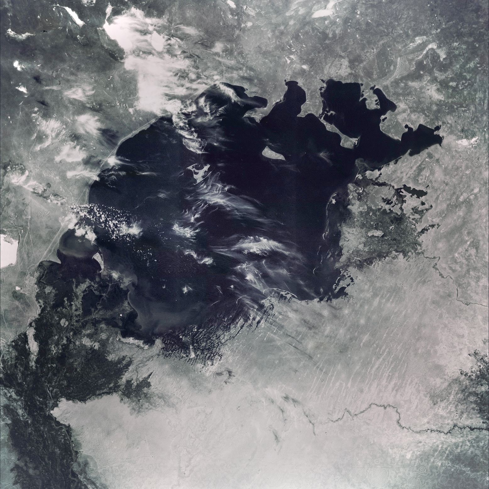
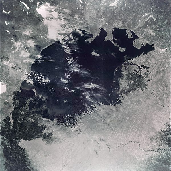
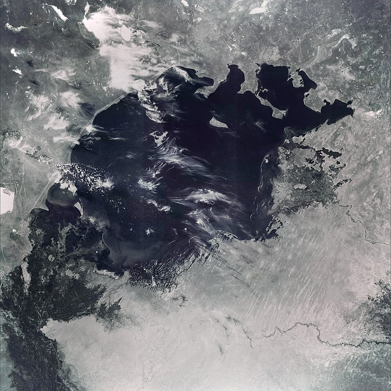
English: This image of the Aral Sea was acquired in August of 1964 by a United States Argon intelligence mapping/geodesy satellite.
KH-5 Mission 9064-A (incorrectly mislabeled 9066-A in the USGS archive) carried the A-22 mapping camera. A TAT-Agena carried this camera into an orbit of 114.96 degrees of inclination with a period of 84 minutes, a perigee of 219 degrees and an apogee of 232 degrees. International Launch Designation: 1964-043A Launch Date: August 21, 1964 Mission Duration: approximately 6 days |
| Көнө | |
| Сығанаҡ | The Aral Sea, Before the Streams Ran Dry - NASA Earth Observatory |
| Автор | Image from the U.S. Air Force KH-5 9066A reconnaissance satellite, the last of the Argon series. |
Лицензиялау
| Этот файл находится в общественном достоянии (англ. public domain), так как он был создан NASA (Национальным управлением по аэронавтике и исследованию космического пространства). Политика авторского права NASA гласит, что «Материал NASA не защищается авторским правом, если не указано иное». (См. Template:PD-USGov, страницу политики авторского права NASA или политику использования изображений JPL.) | ||
 |
Предупреждения:
|
Төп йөкләүҙәр журналы
Первоначальная страница описания находилась здесь. Все нижеперечисленные имена участников относятся к en.wikipedia.
- 2006-07-05 05:48 Hartze11 450×450×8 (35583 bytes) This image of the Aral Sea was acquired in August of 1964 by a United States intelligence mapping satellite.
| Аннотации | Это изображение аннотировано: Просмотреть аннотации на Викискладе |

Файл тарихы
Файлдың күрһәтелгән ваҡытта ниндәй өлгөлә булғанын ҡарар өсөн баҫығыҙ: Дата/ваҡыт
| Дата/ваҡыт | Миниатюра | Үлсәмдәре | Ҡатнашыусы | Иҫкәрмә | |
|---|---|---|---|---|---|
| ағымдағы | 20:11, 30 май 2022 | | 1556 × 1554 (1,11 Мб) | Italyoz484 | Fixed haze. |
| 14:56, 9 сентябрь 2021 |  | 1556 × 1554 (1,08 Мб) | LightandDark2000 | Reverted to version as of 06:33, 5 August 2021 (UTC) That looks worse. | |
| 18:21, 5 сентябрь 2021 |  | 800 × 800 (105 Кб) | PineappIed | more accurate depiction | |
| 18:16, 5 сентябрь 2021 |  | 3930 × 3930 (2,9 Мб) | PineappIed | ||
| 06:33, 5 август 2021 |  | 1556 × 1554 (1,08 Мб) | Italyoz484 | coloration | |
| 10:53, 1 октябрь 2014 |  | 3930 × 3930 (2,9 Мб) | Szczureq | Full resolution found at NASA Earth Observatory (http://earthobservatory.nasa.gov/IOTD/view.php?id=77193) | |
| 22:52, 10 ғинуар 2008 |  | 450 × 450 (35 Кб) | File Upload Bot (Magnus Manske) | {{BotMoveToCommons|en.wikipedia}} {{Information |Description={{en|This image of the Aral Sea was acquired in August of 1964 by a United States Argon intelligence mapping/geodesy satellite. KH-5 Mission 9064-A (incorrectly mislabeled 9066-A in the USGS |
Файл ҡулланыу
Был файлды киләһе бит ҡуллана:
Файлды глобаль ҡулланыу
Был файл түбәндәге википроекттарҙа ҡулланыла:
- de.wikipedia.org проектында ҡулланыу
- it.wikipedia.org проектында ҡулланыу
- km.wikipedia.org проектында ҡулланыу
- nn.wikipedia.org проектында ҡулланыу
- pl.wikipedia.org проектында ҡулланыу
- ru.wikipedia.org проектында ҡулланыу
- ta.wikipedia.org проектында ҡулланыу