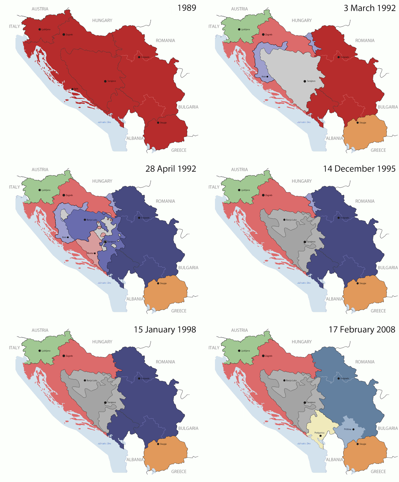
Файл:Breakup of Yugoslavia.gif
Башҡа телдәрҙә был бит юҡ
Викиһаҡлағыстағы файл битенә күсеү
Википедия — ирекле энциклопедия мәғлүмәте

Сығанаҡ файл((1545 × 1242 пиксель, файл күләме: 187 Кб, MIME-төр: image/gif), цикллы, 14 кадр, 44 с)

This image could be re-created using vector graphics as an SVG file. This has several advantages; see Commons:Media for cleanup for more information. If an SVG form of this image is available, please upload it and afterwards replace this template with {{vector version available|new image name}}. It is recommended to name the SVG file "Breakup of Yugoslavia.svg" - then the template Vector version available (or Vva) does not need the new image name parameter.

Ҡыҫҡа аңлатма

Key:

Yugoslavia (1943–1992) SFR Yugoslavia
Croatia (1991–present) Croatia
Herzeg-Bosnia (1992–1994)
UNTAES (1996–1998)
Federal Republic of Yugoslavia / Serbia and Montenegro (1992–2006) Serbia and Montenegro
Republika Srpska (1992–present) Republika Srpska
Serbian Krajina (1991–1995/96)
Republic of Bosnia and Herzegovina (1992–1995)
Bosnia and Herzegovina (1998–present) Bosnia and Herzegovina
Western Bosnia (1993–1995)
Serbia (2006–present) Serbia
Kosovo (under UNMIK control 1999–present; declaration of independence 2008) Kosovo
Montenegro (2006–present) Montenegro
Macedonia (1991–present) Macedonia
Slovenia (1991–present) Slovenia


Тасуирлау

This is an animated GIF that shows the stages of the breakup of the SFR Yugoslavia in the 90's and 2000's. The map based off Morwen's map of the divisions of the SFRY, Which is licensed by the GFDL. The source for the dates of independence is the CIA World Factbook. These maps do not now show the Inter-Entity Boundary Line (IEBL) and/or the entities that are separated by it. The IEBL has been drawn based on this CIA map; the Brčko District has been drawn based on Image:BH municipality location.gif, by user:Ante Perkovic. I might add them in the future.

Since the original map was GFDL, this image is as well.

A map depicting Kosovo's final status is ready once it takes effect.


Changelog for versions 2/3:

Here are some changes in this new build of the map:

  • The Kosovo boundary has been given a shade of red instead of the previous UN blue since they are a province of Serbia under UNIMIK control.
  • Montenegro's color has been changed to a golden shade close to what's on the flag.
  • The IEBL and the Brčko District has been redrawn because I deleted the original map; the color for the Republika Srpska is lighter.
  • The dates are at the top left hand corner of the map instead of the bottom.
  • I have taken a new approach as to the boundaries. Each part of Yugoslavia now shows the boundary on the maps starting the year they broke away. I feel this change helps readers understand the breakup better.
  • The SFRY and the FRY are in different shades since the FRY was never accepted as the successor to the former by the UN.
  • The colors for the entities of BiH have been removed as to not confuse people into thinking that they are independent states. What remains is the IEBL with both entities in green.
  • The Kosovo boundary is finally in hash marks!
  • The Brčko District has been removed. The sale is too small to show accurately.

Changelog for version 4:

  • The map is larger!
  • The image has been rebuilt to include the eastern part of FYR Macedonia.
  • The image has been updated to take in Kosovo's new status.
  • The IEBL is now a darker line.
  • Montenegro, Kosovo, and FRY/SCG/Serbia have new colors!

Changelog for version 5:

  • Rebuilt
  • Larger map: size of base image
  • Accurate Inter-Entity Boundary Line
Көнө 24 July 2006 (orginal upload date)
Сығанаҡ Made by Hoshie; see above for more details on sources.
Автор Hoshie
Башҡа өлгөләр

Лицензиялау

GNU head Был документты Ирекле программа тәьминәте фонды тарафынан баҫтырылған GNU Free Documentation License рөхсәтнамәһенең 1.2 йәки һуңғыраҡ өлгөһө шарттарына ярашлы даими бүлектәрһеҙ, тәүге һәм аҙаҡҡы тышлыҡтарға урынлаштырыла торған текстарһыҙ күсереп алыу, таратыу һәм/йәки үҙгәртеү рөхсәт ителә. Рөхсәтнамәнең күсермәһен GNU Free Documentation License бүлегендә ҡарағыҙ.
w:ru:Creative Commons
авторлыҡты асыҡлау шул уҡ шарттарҙа
Был файл Creative Commons Attribution-Share Alike 3.0 Unported лицензияһы буйынса рөсхәт ителә.
Һеҙгә мөмкин:
  • бүлешергә – эште күсереп алырға, таратырға һәм тапшырырға
  • үҙгәртергә – эште яраҡлаштырырға
Түбәндәге шарттарҙа:
  • авторлыҡты асыҡлау – Авторлыҡты, лицензияға һылтанманы һәм авторҙың ниндәй ҙә булһа үҙгәрештәр индергәнме-юҡмы икәнлеген күрһәтергә тейешһегеҙ. Быны теләһә ниндәй ысул менән эшләргә мөмкин, әммә лицензиат һеҙгә ярҙам иткән йәки ошо әҫәрҙе ҡулланыуығыҙҙы хуплаған тигән тойғо тыуырға тейеш түгел.
  • шул уҡ шарттарҙа – Әгәр һеҙ был әҫәрҙе үҙгәртәһегеҙ, уның нигеҙендә яңы әҫәр яҙаһығыҙ икән, сығанаҡ әҫәр рөхсәтнамәһен йәки шуға тура килә торған лицензия ҡулланырға тейешһегеҙ.
Был лицензия тамғаһы файлға GFDL лицензияһын яңыртыу өлөшө булараҡ өҫтәлгән.

Краткие подписи

Добавьте однострочное описание того, что собой представляет этот файл

Элементы, изображённые на этом файле

һүрәтләнгән объект

У этого свойства есть некоторое значение без элемента в

MIME-тип русский

image/gif

05ca2aefea8406b809968643552d5095c847a42f

иҫәп төрө: SHA-1 русский

191 625 байт

44 секунд

1242 пиксель

1545 пиксель

Файл тарихы

Файлдың күрһәтелгән ваҡытта ниндәй өлгөлә булғанын ҡарар өсөн баҫығыҙ: Дата/ваҡыт

(Иң һуңғылар | Иң тәүгеләр) (һуңғы 10 | ) (10 | 20 | 50 | 100 | 250 | 500) ҡарарға
Дата/ваҡытМиниатюраҮлсәмдәреҠатнашыусыИҫкәрмә
ағымдағы07:40, 17 июль 201607:40, 17 июль 2016 өлгөһө өсөн миниатюра1545 × 1242 (187 Кб)מפתח-רשימהReverted to version as of 17:22, 21 August 2015 (UTC)
17:22, 21 август 201517:22, 21 август 2015 өлгөһө өсөн миниатюра1463 × 1158 (1,81 Мб)BraganzaReverted to version as of 03:57, 19 January 2010
17:22, 21 август 201517:22, 21 август 2015 өлгөһө өсөн миниатюра1545 × 1242 (187 Кб)BraganzaReverted to version as of 01:02, 19 December 2011
17:15, 21 август 201517:15, 21 август 2015 өлгөһө өсөн миниатюра120 × 95 (3 Кб)Braganza03:57, 19. Jan. 2010
01:02, 19 декабрь 201101:02, 19 декабрь 2011 өлгөһө өсөн миниатюра1545 × 1242 (187 Кб)DIREKTORAdded details
18:09, 27 июль 201118:09, 27 июль 2011 өлгөһө өсөн миниатюра1545 × 1242 (170 Кб)DIREKTORSmall fixes
17:28, 27 июль 201117:28, 27 июль 2011 өлгөһө өсөн миниатюра1545 × 1242 (171 Кб)DIREKTORAdded UNMIK
16:38, 27 июль 201116:38, 27 июль 2011 өлгөһө өсөн миниатюра1545 × 1242 (165 Кб)DIREKTORDates for the last two frames.
12:10, 27 июль 201112:10, 27 июль 2011 өлгөһө өсөн миниатюра1545 × 1242 (149 Кб)DIREKTORLighter shade for country names
16:59, 26 июль 201116:59, 26 июль 2011 өлгөһө өсөн миниатюра1545 × 1242 (170 Кб)DIREKTORHigher res plus details
(Иң һуңғылар | Иң тәүгеләр) (һуңғы 10 | ) (10 | 20 | 50 | 100 | 250 | 500) ҡарарға

Был файлды киләһе бит ҡуллана:

Файлды глобаль ҡулланыу

Был файл түбәндәге википроекттарҙа ҡулланыла:

Был файлды глобаль ҡулланыуҙы ҡарарға.

Метамәғлүмәттәр