
Файл:Franz Josef Land, Aug 2011.jpg
Сығанаҡ файл ((2400 × 1800 пиксель, файл күләме: 812 Кб, MIME-төр: image/jpeg))
Был файл һаҡлау урыны Викиһаҡлағыста һаҡлана. Уның тураһында мәғлүмәттәр түбәндә күрһәтелгән.
Викиһаҡлағыс — Викимедиа проекттарында ҡулланылған ирекле файлдар өсөн үҙәкләштерелгән һаҡлағыс. |
Ҡыҫҡа аңлатма
| Тасуирлау |
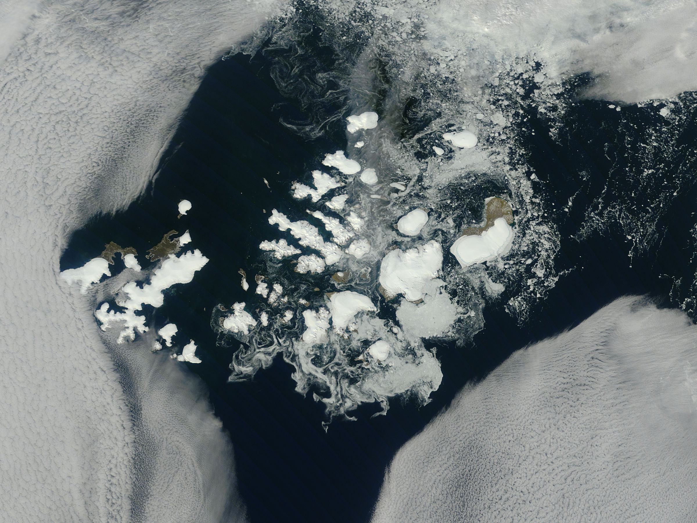
NASA image captured this true-color image on August 14, 2011 The clouds parted over the northeast Barents Sea region of the Arctic Ocean in late summer allowing a view of the ice-covered islands of Franz Josef Land (Russia) forming a stark-white contrast to the surrounding dark sea water. The Moderate Resolution Imaging Spectroradiometer (MODIS) aboard the Terra satellite captured this true-color image on August 14, 2011. Franz Josef Land is an archipelago of 6 main islands and about 135 small islands, with a total landmass of about 16,134 square kilometers (6,229 square miles). The terrain is primarily elevated table lands and low hills, with the highest point rising to 620 m (2034 feet). The glaciers on the islands of Franz Josef are currently in a state of retreat, and in this image large areas of the main islands clearly appear ice free. However, up to 85% of the island’s landmass is permanently ice-covered, with an average ice thickness of about 180 m (590 feet). On Graham Bell Island —the large island on the eastern edge of the group— the Windy Dome Ice Cap reaches a depth of greater than 500 m (1,640 feet). Although being late summer, sea ice can still be seen surrounding many of the islands. Credit: NASA/GSFC/Jeff Schmaltz/MODIS Land Rapid Response Team NASA Goddard Space Flight Center enables NASA’s mission through four scientific endeavors: Earth Science, Heliophysics, Solar System Exploration, and Astrophysics. Goddard plays a leading role in NASA’s accomplishments by contributing compelling scientific knowledge to advance the Agency’s mission. Follow us on Twitter Like us on Facebook Find us on Instagram |
| Көнө | |
| Сығанаҡ |
Franz Josef Land, Arctic Ocean
|
| Автор | NASA Goddard Space Flight Center from Greenbelt, MD, USA |
Лицензиялау
| Этот файл находится в общественном достоянии (англ. public domain), так как он был создан NASA (Национальным управлением по аэронавтике и исследованию космического пространства). Политика авторского права NASA гласит, что «Материал NASA не защищается авторским правом, если не указано иное». (См. Template:PD-USGov, страницу политики авторского права NASA или политику использования изображений JPL.) | ||
 |
Предупреждения:
|
- Һеҙгә мөмкин:
- бүлешергә – эште күсереп алырға, таратырға һәм тапшырырға
- үҙгәртергә – эште яраҡлаштырырға
- Түбәндәге шарттарҙа:
- авторлыҡты асыҡлау – Авторлыҡты, лицензияға һылтанманы һәм авторҙың ниндәй ҙә булһа үҙгәрештәр индергәнме-юҡмы икәнлеген күрһәтергә тейешһегеҙ. Быны теләһә ниндәй ысул менән эшләргә мөмкин, әммә лицензиат һеҙгә ярҙам иткән йәки ошо әҫәрҙе ҡулланыуығыҙҙы хуплаған тигән тойғо тыуырға тейеш түгел.
| Это изображение, изначально опубликованное на Flickr, было досмотрено August 31, 2011 администратором или доверенным пользователем File Upload Bot (Magnus Manske), который подтвердил, что на тот момент оно было доступно на Flickr на условиях указанной лицензии. |
Файл тарихы
Файлдың күрһәтелгән ваҡытта ниндәй өлгөлә булғанын ҡарар өсөн баҫығыҙ: Дата/ваҡыт
| Дата/ваҡыт | Миниатюра | Үлсәмдәре | Ҡатнашыусы | Иҫкәрмә | |
|---|---|---|---|---|---|
| ағымдағы | 21:04, 31 август 2011 | | 2400 × 1800 (812 Кб) | File Upload Bot (Magnus Manske) | {{Information |Description=NASA image captured this true-color image on August 14, 2011 The clouds parted over the northeast Barents Sea region of the Arctic Ocean in late summer, 2011 allowing a view of the ice-covered islands of Franz Josef Land, Russi |
Файл ҡулланыу
Был файлды киләһе бит ҡуллана:
Файлды глобаль ҡулланыу
Был файл түбәндәге википроекттарҙа ҡулланыла:
- af.wikipedia.org проектында ҡулланыу
- ar.wikipedia.org проектында ҡулланыу
- avk.wikipedia.org проектында ҡулланыу
- az.wikipedia.org проектында ҡулланыу
- ca.wikipedia.org проектында ҡулланыу
- cs.wikipedia.org проектында ҡулланыу
- cv.wikipedia.org проектында ҡулланыу
- da.wikipedia.org проектында ҡулланыу
- de.wikipedia.org проектында ҡулланыу
- el.wikipedia.org проектында ҡулланыу
- en.wikipedia.org проектында ҡулланыу
- fr.wikipedia.org проектында ҡулланыу
- lt.wikipedia.org проектында ҡулланыу
- oc.wikipedia.org проектында ҡулланыу
- pl.wikipedia.org проектында ҡулланыу
- ru.wikipedia.org проектында ҡулланыу
- sco.wikipedia.org проектында ҡулланыу
- simple.wikipedia.org проектында ҡулланыу
- vi.wikipedia.org проектында ҡулланыу