
Файл:Samsi Addu.PNG
Ҡарап сығыу ваҡытындағы күләм: 761 × 600 пиксель. Башҡа айырыусанлыҡтар: 305 × 240 пиксель | 609 × 480 пиксель | 996 × 785 пиксель.
Сығанаҡ файл ((996 × 785 пиксель, файл күләме: 1,08 Мб, MIME-төр: image/png))
Был файл һаҡлау урыны Викиһаҡлағыста һаҡлана. Уның тураһында мәғлүмәттәр түбәндә күрһәтелгән.
Викиһаҡлағыс — Викимедиа проекттарында ҡулланылған ирекле файлдар өсөн үҙәкләштерелгән һаҡлағыс. |
| Тасуирлау |
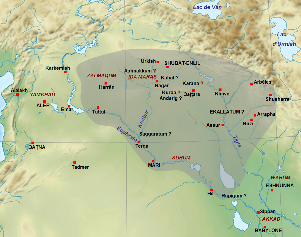
English: Map of the approximate extension of the kingdom of Samsi-Addu/Shamshi-Adad (1815-1775 BC) just before his death, with the territories given to his sons Ishme-Dagan (around Ekallatum) and Yasmakh-Addu (around Mari). The names of cities in capitals letters are the capitals of the main kingdoms of the Middle East at this time. The names of cities with question mark are for uncertain locations. Adapted from F. Joannès (dir.), Dictionnaire de la civilisation mésopotamienne, Paris, 2001, p. 751 (map by M. Sauvage) and D. Charpin, Hammu-rabi de Babylone, Paris, 2003, p. 306. Français : Carte de l'extension approximative du royaume de Samsi-Addu/Shamshi-Adad (1815-1775 av. J.-C.) juste avant sa mort, avec les territoires attribués à ses fils Ishme-Dagan (atour d'Ekallatum) et Yasmakh-Addu (autour de Mari). Les noms de villes en majuscules indiquent les capitales des principaux royaumes du Moyen-Orient à cette période. Les noms de villes avec des points d'interrogation indiquent les villes donc la localisation est incertaine. Adapté de F. Joannès (dir.), Dictionnaire de la civilisation mésopotamienne, Paris, 2001, p. 751 (carte de M. Sauvage) et de D. Charpin, Hammu-rabi de Babylone, Paris, 2003, p. 306. |
| Көнө | (UTC) |
| Сығанаҡ | |
| Автор |
|
| Это отретушированное изображение, что означает, что первоначальной версия изображения была изменена цифровым способом. Изменения: Ajout de l'extension du royaume de Samsi-Addu, des noms de villes et de certaines régions.. Оригинал доступен по ссылке: Near East topographic map-blank.svg:
|
Мин, был эшкә авторлыҡ хоҡуҡтары эйәһе, үҙ теләгем менән уны түбәндәге лицензиялар шарттарына ярашлы баҫтырып сығарам:
Файл Creative Commons нигеҙендә-шул уҡ шарттар менән 3.0 Дөйөм, 2.5 Дөйөм, 2.0 Дөйөм һәм 1.0 Дөйөм лицензиялары буйынса ҡулланыла.
- Һеҙгә мөмкин:
- бүлешергә – эште күсереп алырға, таратырға һәм тапшырырға
- үҙгәртергә – эште яраҡлаштырырға
- Түбәндәге шарттарҙа:
- авторлыҡты асыҡлау – Авторлыҡты, лицензияға һылтанманы һәм авторҙың ниндәй ҙә булһа үҙгәрештәр индергәнме-юҡмы икәнлеген күрһәтергә тейешһегеҙ. Быны теләһә ниндәй ысул менән эшләргә мөмкин, әммә лицензиат һеҙгә ярҙам иткән йәки ошо әҫәрҙе ҡулланыуығыҙҙы хуплаған тигән тойғо тыуырға тейеш түгел.
- шул уҡ шарттарҙа – Әгәр һеҙ был әҫәрҙе үҙгәртәһегеҙ, уның нигеҙендә яңы әҫәр яҙаһығыҙ икән, сығанаҡ әҫәр рөхсәтнамәһен йәки шуға тура килә торған лицензия ҡулланырға тейешһегеҙ.

|
Был документты Ирекле программа тәьминәте фонды тарафынан баҫтырылған GNU Free Documentation License рөхсәтнамәһенең 1.2 йәки һуңғыраҡ өлгөһө шарттарына ярашлы даими бүлектәрһеҙ, тәүге һәм аҙаҡҡы тышлыҡтарға урынлаштырыла торған текстарһыҙ күсереп алыу, таратыу һәм/йәки үҙгәртеү рөхсәт ителә. Рөхсәтнамәнең күсермәһен GNU Free Documentation License бүлегендә ҡарағыҙ. |
Һеҙ лицензияның үҙегеҙ теләгәнен һайлай алаһығыҙ.
Төп йөкләүҙәр журналы
This image is a derivative work of the following images:
- File:Near_East_topographic_map-blank.svg licensed with Cc-by-sa-3.0,2.5,2.0,1.0, GFDL
- 2009-08-18T18:31:37Z Sémhur 2425x1581 (2442670 Bytes) 3 - New try
- 2009-08-17T15:39:22Z Sémhur 2425x1581 (1815374 Bytes) 2 - With the background...
- 2009-08-17T15:37:36Z Sémhur 2425x1581 (2836 Bytes) {{Information |Description={{en|1=Blank physical map of the [[:en:Near East|Near East]]}} {{fr|1=Carte physique vierge du [[:fr:Proche-Orient|Proche-Orient]].}} |Source={{own}} |Author=[[User:Sémhur|Sémhur]] |Date=2008-08-1
Uploaded with derivativeFX
Файл тарихы
Файлдың күрһәтелгән ваҡытта ниндәй өлгөлә булғанын ҡарар өсөн баҫығыҙ: Дата/ваҡыт
| Дата/ваҡыт | Миниатюра | Үлсәмдәре | Ҡатнашыусы | Иҫкәрмә | |
|---|---|---|---|---|---|
| ағымдағы | 10:25, 28 сентябрь 2010 | | 996 × 785 (1,08 Мб) | Zunkir | {{Information |Description={{en|1=Map of the approximate extension of the kingdom of Samsi-Addu/Shamshi-Adad (1815-1775 BC) just before his death, with the territories given to his sons Ishme-Dagan (around Ekallatum) and Yasmakh-Addu (around Mari). The na |
Файл ҡулланыу
Был файлды киләһе бит ҡуллана:
Файлды глобаль ҡулланыу
Был файл түбәндәге википроекттарҙа ҡулланыла:
- am.wikipedia.org проектында ҡулланыу
- ar.wikipedia.org проектында ҡулланыу
- arz.wikipedia.org проектында ҡулланыу
- bn.wikipedia.org проектында ҡулланыу
- br.wikipedia.org проектында ҡулланыу
- ca.wikipedia.org проектында ҡулланыу
- cs.wikipedia.org проектында ҡулланыу
- de.wikipedia.org проектында ҡулланыу
- en.wikipedia.org проектында ҡулланыу
- es.wikipedia.org проектында ҡулланыу
- fa.wikipedia.org проектында ҡулланыу
- fi.wikipedia.org проектында ҡулланыу
- fr.wikipedia.org проектында ҡулланыу
Был файлды глобаль ҡулланыуҙы ҡарарға.