
Файл:Golan heights rel89B.jpg

Ҡарап сығыу ваҡытындағы күләм: 468 × 599 пиксель. Башҡа айырыусанлыҡтар: 187 × 240 пиксель | 375 × 480 пиксель | 1022 × 1308 пиксель.
Сығанаҡ файл ((1022 × 1308 пиксель, файл күләме: 231 Кб, MIME-төр: image/jpeg))
Был файл һаҡлау урыны Викиһаҡлағыста һаҡлана. Уның тураһында мәғлүмәттәр түбәндә күрһәтелгән.
Викиһаҡлағыс — Викимедиа проекттарында ҡулланылған ирекле файлдар өсөн үҙәкләштерелгән һаҡлағыс. |
Ҡыҫҡа аңлатма
| Тасуирлау |
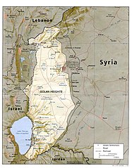
English: I created this image myself, by modifying the existing Image:Golan_heights_rel89A.jpg, which was itself a modified version of a modified CIA (and hence public domain) Image:Golan_92.jpg. Previous modifications were done to provide a map that was impartial about the contentious issue of which country owns the Golan Heights. The previous modifications were effective in creating a neutral map by removing the names "Syria" and "Israel" from the contentious territory and left only the label "Golan Heights". The present modification was intended solely to restore the names and locations of villages that were included on the original CIA map but had been (inadvertently) moved or erased by relocating the country titles. Due to the recurrent conflict involving villages and settlements within the Golan Heights, I feel that it is important to retain the locations on the map. As with the earlier modifications of this file, I hope that this modification will be seen as a fair compromise that also maintains the cartographical accuracy of map. I make no copyright claim on my modification; its copyright status is the same as its source. dp_roberson 15:44, 21 October 2007 (UTC) |
| Көнө | 21 сентябрь 2007 (дата первоначальной загрузки файла на вики) |
| Сығанаҡ | Перенесено с en.wikipedia на Викисклад. |
| Автор | Dp roberson из английский Википедия |
Лицензиялау
| Был эш авторы Dp roberson из английский Википедия тарафынан йәмәғәт милекенә ҡулланыуға тапшырылған. Был рөхсәт бөтә донъяла ғәмәлдә. Ҡайһы бер илдәрҙә был хоҡуҡи йәһәттән мөмкин булмауы ихтимал; был осраҡта: Dp roberson һәр кемгә был эште төрлө маҡсаттарҙа бер ниндә шарттарһыҙ, әгәр улар ҡанун буйынса талап ителмәһә, ҡулланырға рөхсәт итә. |
Төп йөкләүҙәр журналы
Первоначальная страница описания находилась здесь. Все нижеперечисленные имена участников относятся к en.wikipedia.
- 2008-12-29 03:13 كهيعص 1022×1308× (236080 bytes) added 4 villages to the map
- 2007-09-21 15:45 Dp roberson 1022×1308× (226330 bytes) I created this image myself, by modifying the existing Image:Golan_heights_rel89A.jpg, which was itself a modified version of a modified CIA (and hence public domain) Image:Golan_92.jpg. Previous modifications were done to provide a map that was impartia
Файл тарихы
Файлдың күрһәтелгән ваҡытта ниндәй өлгөлә булғанын ҡарар өсөн баҫығыҙ: Дата/ваҡыт
| Дата/ваҡыт | Миниатюра | Үлсәмдәре | Ҡатнашыусы | Иҫкәрмә | |
|---|---|---|---|---|---|
| ағымдағы | 04:56, 27 ғинуар 2015 | | 1022 × 1308 (231 Кб) | Magog the Ogre | Reverted to version as of 22:56, 25 January 2015 |
| 22:56, 25 ғинуар 2015 |  | 468 × 599 (257 Кб) | OgreBot | (BOT): Reverting to most recent version before archival | |
| 22:56, 25 ғинуар 2015 |  | 1022 × 1308 (231 Кб) | OgreBot | (BOT): Uploading old version of file from en.wikipedia; originally uploaded on 2008-12-29 03:13:42 by كهيعص | |
| 13:20, 22 сентябрь 2010 |  | 468 × 599 (257 Кб) | Ravpapa | Added the words "(Israeli occupied)" under the words "Golan Heights". This makes it clear that the area is occupied. | |
| 08:53, 5 март 2008 |  | 1022 × 1308 (221 Кб) | Cansado | {{Information |Description={{en|I created this image myself, by modifying the existing Image:Golan_heights_rel89A.jpg, which was itself a modified version of a modified CIA (and hence public domain) Image:Golan_92.jpg. Previous modifications were done to |
Файл ҡулланыу
Был файлды киләһе бит ҡуллана:
Файлды глобаль ҡулланыу
Был файл түбәндәге википроекттарҙа ҡулланыла:
- ar.wikipedia.org проектында ҡулланыу
- de.wikinews.org проектында ҡулланыу
- en.wikipedia.org проектында ҡулланыу
- ru.wikipedia.org проектында ҡулланыу
- tr.wikipedia.org проектында ҡулланыу