
Файл:Lizars Mexico & Guatimala 1831 UTA.jpg
Ҡарап сығыу ваҡытындағы күләм: 708 × 600 пиксель. Башҡа айырыусанлыҡтар: 283 × 240 пиксель | 567 × 480 пиксель | 907 × 768 пиксель | 1209 × 1024 пиксель | 2418 × 2048 пиксель | 6185 × 5238 пиксель.
Сығанаҡ файл ((6185 × 5238 пиксель, файл күләме: 11,59 МБ, MIME-төр: image/jpeg))
Был файл һаҡлау урыны Викиһаҡлағыста һаҡлана. Уның тураһында мәғлүмәттәр түбәндә күрһәтелгән.
Викиһаҡлағыс — Викимедиа проекттарында ҡулланылған ирекле файлдар өсөн үҙәкләштерелгән һаҡлағыс. |
Ҡыҫҡа аңлатма
| Атамаһы |
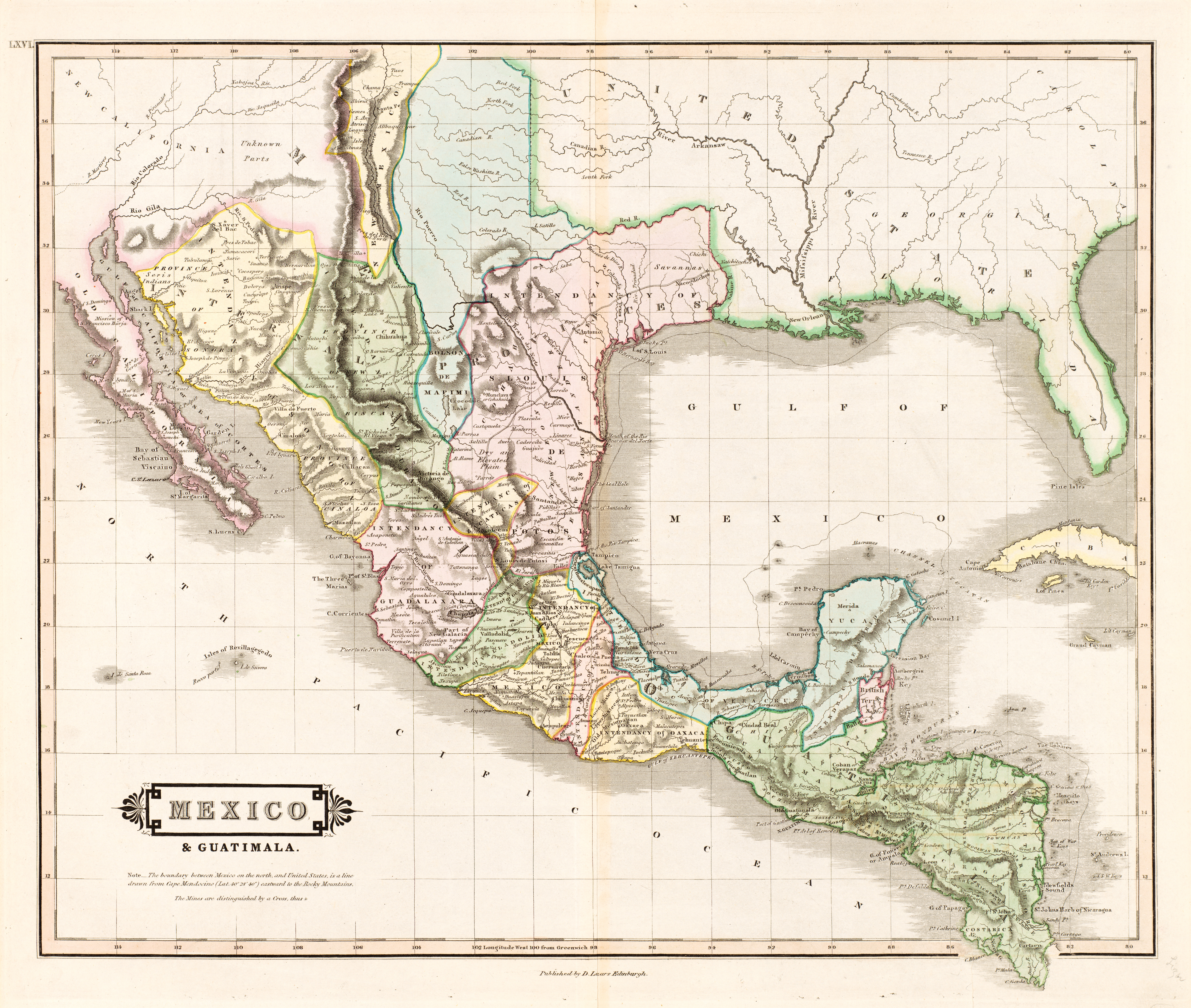
English: Mexico & Guatimala [sic] |
||||||||||||||||||||||||||
| Описание |
English: The creator of this map was probably Daniel Lizars II (1793-1875), the son of Edinburgh map engraver and publisher Daniel Lizars I (1754-1812) and younger brother of William Home Lizars (1788-1859). Shortly after producing the map, Daniel II went bankrupt in 1832 and emigrated to Canada in 1833. Lizars' map shows Mexico's administrative districts as Intendencies (Intendencias) and Internal Provinces (Provincias Internas) dating from the Spanish era. His depiction of the area that became Texas is notably jarring to modern viewers because his map further exaggerated some of the cartographic errors of his predecessors and contemporaries: particularly, a southerly "dip" of the middle Red River and the southerly courses of the Trinity, Brazos, and Colorado Rivers (which actually flow southeasterly). Settlements shown include Nacogdoches, "St." Antonio, and "Loredo". Interestingly, Lizars included the "British Territory" that became British Honduras or Belize. British logging settlements existed in the territory by the late eighteenth century and, although the British government had been hesitant to create a colony for fear of provoking the Spanish, settlers there were largely self-governing. |
||||||||||||||||||||||||||
| Көнө | около 1831 | ||||||||||||||||||||||||||
| Сығанаҡ | UTA Libraries Cartographic Connections: карта / текст | ||||||||||||||||||||||||||
| Булдырыусы |
|
||||||||||||||||||||||||||
| Дополнительная информация |
English: The University of Texas at Arlington Libraries Special Collections, Gift of Virginia Garrett |
||||||||||||||||||||||||||
| Geotemporal data | |||||||||||||||||||||||||||
| Map location |
Мексика Гватемала Техас |
||||||||||||||||||||||||||
| Georeferencing | If inappropriate please set warp_status = skip to hide. | ||||||||||||||||||||||||||
| Bibliographic data | |||||||||||||||||||||||||||
| Баҫма |
The Edinburgh Geographical and Historical Atlas |
||||||||||||||||||||||||||
| Автор |
John Hamilton |
||||||||||||||||||||||||||
| Баҫтырыу урыны |
Эдинбург Лондон Дублин |
||||||||||||||||||||||||||
| Нәшриәт |
John Hamilton Whittaker, Treacher & Co. W. Curry, Jun. & Co. |
||||||||||||||||||||||||||
| Archival data | |||||||||||||||||||||||||||
| Коллекция |
|
||||||||||||||||||||||||||
| Дәүмәлдәр | бейеклек: 42 см; киңлек: 51,5 см | ||||||||||||||||||||||||||
| Мөхит | colored engraving on paper | ||||||||||||||||||||||||||
| artwork-references |
Worms, Laurence; Ashley Baynton-Williams (2011) British Map Engravers, Лондон: Rare Book Society, стр. 406–409 |
||||||||||||||||||||||||||
| Башҡа өлгөләр | |||||||||||||||||||||||||||
.jpg)
Лицензиялау

|
This file was provided to Wikimedia Commons by the University of Texas at Arlington Libraries as part of a cooperation project. The University of Texas at Arlington Libraries is part of the University of Texas at Arlington, a public research university located in Arlington, Texas.
|
|
Это произведение находится в общественном достоянии в тех странах, где срок охраны авторского права равен жизни автора плюс 100 лет и менее. Это произведение находится в общественном достоянии (англ. public domain) в США, так как оно было опубликовано до 1 января 1929 года. | |
| Был файл билдәле авторлыҡ хоҡуҡтары, шулай уҡ бәйле һәм йәнәш хоҡуҡтар сикләүҙәренән азат, тип билдәләнгән. | |
Файл тарихы
Файлдың күрһәтелгән ваҡытта ниндәй өлгөлә булғанын ҡарар өсөн баҫығыҙ: Дата/ваҡыт
| Дата/ваҡыт | Миниатюра | Үлсәмдәре | Ҡатнашыусы | Иҫкәрмә | |
|---|---|---|---|---|---|
| ағымдағы | 13:26, 13 июль 2019 | | 6185 × 5238 (11,59 МБ) | Michael Barera | == {{int:filedesc}} == {{Map |title = ''Mexico & Guatimala'' [sic] |description = {{en|The creator of this map was probably Daniel Lizars II (1793-1875), the son of Edinburgh map engraver and publisher Daniel Lizars I (1754-1812) and younger brother of William Home Lizars (1788-1859). Shortly after producing the map, Daniel II went bankrupt in 1832 and emigrated to Canada in 1833. Lizars' map shows Mexico's administrative districts as Intendencies (''Intendencias'') and In... |
Файл ҡулланыу
Был файлды ҡулланған биттәр юҡ.
Файлды глобаль ҡулланыу
Был файл түбәндәге википроекттарҙа ҡулланыла:
- en.wikipedia.org проектында ҡулланыу
- es.wikipedia.org проектында ҡулланыу
- hr.wikipedia.org проектында ҡулланыу
- sh.wikipedia.org проектында ҡулланыу